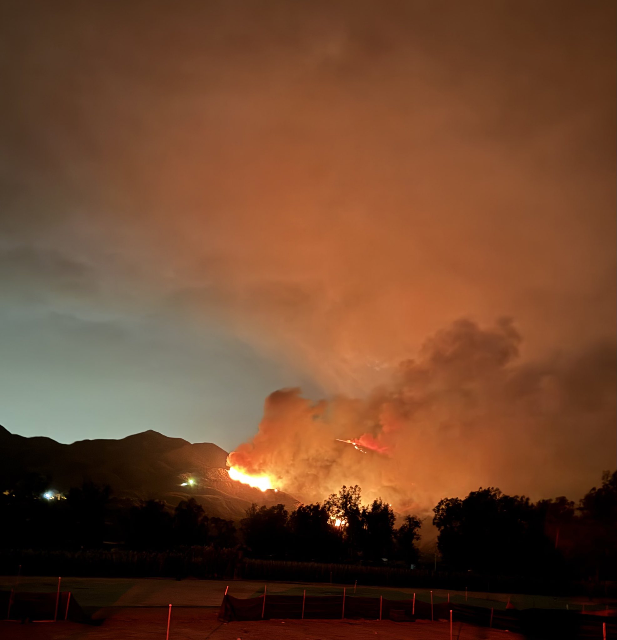
A fire broke out in Trabuco Canyon near a remote-controlled airplane field on Monday afternoon, growing significantly in size and leading to mandatory evacuation orders. The Airport Fire has burned approximately 5,432 acres in Trabuco Canyon, a mountainous community north of Rancho Santa Margarita in Orange County.
The Orange County Fire Department responded to the fire around 1:30 p.m., initially finding a 7-acre fire in a dry forest. Crews battled the flames from the ground and air, using “hand crews, bulldozers, helicopters, and fixed-wing aircraft.” By 3:00 p.m., the fire had grown to around 292 acres, and by 4:30 p.m., it reached 1,860 acres. Large plumes of smoke could be seen throughout the area, and Sky5 video showed large flames burning up a steep hillside. By 9.30 pm the fire had engulfed 5,432 acres, as the fire dept continued to fight throughout the night.
Mandatory evacuation orders were issued for residents of Robinson Ranch, Trabuco Highlands, the Trabuco Highland apartment complex, and Meander Lane. Voluntary evacuation advisories were issued for Rose Canyon Road, Trabuco Creek Road, Trabuco Canyon Road, Trabuco Oaks Road, Joplin Loop, and Cook’s Corner. Deputies from the Orange County Sheriff’s Department went door to door to notify and enforce the evacuation order.
A “long-term care and reception shelter” was established at the Rancho Santa Margarita Bell Tour Regional Community Center. A temporary evacuation site was also set up at the Lake Forest Sports Complex. For large animals, a shelter was set up at the Orange County Fairgrounds in Costa Mesa. Mission Viejo Animal Services set up a meeting and reunion point in the Ralphs parking lot to help area residents reunite with their pets.
Similar Posts
The Orange County Sheriff’s Department announced road closures at several intersections, including Plano Trabuco Drive and Joshua Drive, Trabuco Drive and Robinson Ranch Road, Antonio Parkway and Alas de Paz, Trabuco Canyon Road and Trabuco Creek Road, Santa Margarita Parkway and Antonio Parkway, and Avenida Empresa and Santa Margarita Parkway.
The Airport Fire is one of several fires occurring in Southern California during a dangerous heatwave, creating hazardous conditions. Temperatures reaching triple digits, exceeding 110°F in some areas, are expected to persist until Monday night. The National Weather Service predicts a drop in temperatures starting Tuesday. Critical fire weather conditions are expected to persist until Tuesday or Wednesday, with evening wind gusts continuing throughout the week and periods of strong winds in the mountains.
Other significant fires in the region include:
- Line Fire (San Bernardino County): Burning along the edge of the San Bernardino National Forest, near Highland. It has scorched 23,600 acres with only 3% containment, threatening approximately 36,328 structures.
- Bridge Fire (Los Angeles County): Started on September 8 near East Fork Road and Glendora Mountain Road in the Angeles National Forest. As of Monday morning, it remained out of control with 0% containment.
- Roblar and Rice Fires (San Diego County): The Roblar Fire has consumed 950 acres, while the Rice Fire is at 20 acres. Both fires are currently 25% contained.
- Coffee Pot Fire (Tulare County): Has burned 13,534 acres since August 3, 2024, with 27% containment.
Cal Fire reports that there are currently around 6,000 fires burning across California, with more than a dozen of them covering over 10 acres. The cause of the Airport Fire remains under investigation by Orange County authorities. For more emergency information and evacuation details regarding the Airport Fire, consult the Orange County Sheriff’s Department website.
