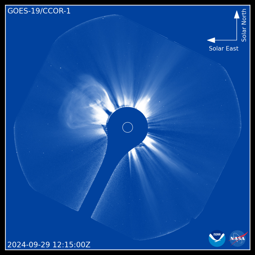
NOAA’s release of imagery from the Compact Coronagraph-1 (CCOR-1) on the GOES-19 satellite marks an unprecedented advancement in space weather monitoring. Developed to detect and monitor coronal mass ejections (CMEs), CCOR-1 is the world’s first operational, space-based coronagraph and a significant leap in efforts to protect Earth from solar-induced disruptions.
What is CCOR-1?
The Compact Coronagraph-1 is positioned on NOAA’s GOES-19 satellite, part of NOAA’s Geostationary Operational Environmental Satellite (GOES) series, which orbits approximately 22,236 miles (35,786 km) above Earth. Unlike ground-based systems, CCOR-1 operates without atmospheric interference, providing NOAA’s Space Weather Prediction Center (SWPC) with consistent, precise imagery of the sun’s corona. This allows for enhanced monitoring of CMEs, critical as they can disrupt satellite operations, navigation systems, and power grids on Earth.
Why Is This Important?
Coronal mass ejections are massive bursts of solar material and magnetic fields from the sun, and they pose significant risks to our technology-driven world. Geomagnetic storms from CMEs can disrupt telecommunications, induce harmful currents in power lines, and damage infrastructure like pipelines. This new system enables NOAA to provide timely, accurate forecasts and warnings as space technology and our reliance on GPS and satellites increase worldwide.
A Milestone for Space Weather Monitoring
CCOR-1 represents a much-needed upgrade in space weather prediction technology. Traditional systems have relied on aging ground-based instruments, limiting the SWPC’s ability to deliver real-time, comprehensive data. With the space-based CCOR-1, NOAA can track the speed, size, and trajectory of CMEs with unprecedented accuracy.
The Development Path for CCOR-1
This innovative instrument was developed by NOAA in partnership with other federal agencies and designed specifically to fit within the compact dimensions required for GOES satellites. The project took years of research, testing, and technical troubleshooting to ensure CCOR-1 could meet the high demands of autonomous space weather monitoring while operating within the size and power constraints necessary for satellite deployment.
Similar Posts
Technical Innovations: What Sets CCOR-1 Apart
CCOR-1’s design is remarkable for its compactness, low weight, and ability to provide high-resolution images autonomously. The coronagraph is programmed to scan the sun’s outer atmosphere continuously and autonomously, enabling scientists to quickly detect changes and analyze potential impacts on Earth. This near-real-time capability enhances NOAA’s capacity for rapid response, giving critical infrastructure operators and the public time to prepare for possible solar impacts.
The Broader Impacts and Future Potential
The addition of CCOR-1 to NOAA’s space weather monitoring toolkit reflects the growing need for resilient, reliable systems in the face of global technological interdependence. As precision GPS systems and satellite communications become more crucial to economic and infrastructure stability, protecting these systems from space weather disruptions is more important than ever.
NOAA’s broader plans aim to incorporate CCOR-1 data across a network of space weather monitoring tools, potentially including future GOES satellites and international collaborations to better track and analyze solar activity. Such collaborations, involving international space agencies and global observation networks, could help expand both the frequency and range of solar observations.
CCOR-1’s Role in the Global Space Weather Monitoring Network
CCOR-1’s operational data will work alongside complementary instruments like NASA’s Solar and Heliospheric Observatory (SOHO) and ESA’s Solar Orbiter, enhancing NOAA’s space weather prediction capability. This integration is essential, as it provides a more complete picture of solar activity, with data from different instruments helping to confirm and refine CME predictions.
“CCOR-1 is the first in a series of NOAA coronagraphs. Similar instruments will be placed on the sun-Earth line and around the sun, as part of NOAA’s Space Weather Follow-On and Space Weather Next programs, respectively,.” mentioned NOAA.
Looking Ahead for Space Weather Monitoring
While CCOR-1 is a vital addition, NOAA’s GOES satellites and similar technologies are expected to evolve, with plans for continued innovation and expanded partnerships. As solar activity increases over Solar Cycle 25, NOAA and its international counterparts will continue to closely monitor space weather patterns.
NOAA’s latest imagery represents an important step forward, offering both scientists and the public critical insights into space weather’s potential impacts and helping to improve preparedness in the face of the sun’s dynamic behavior.
