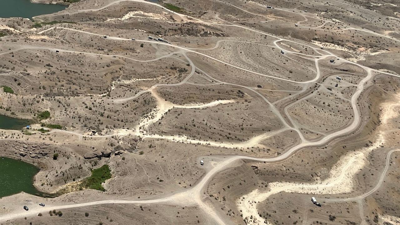
The once-pristine desert landscape surrounding Lake Mead now bears the scars of 824 documented miles of unauthorized vehicular paths, with aerial surveys suggesting this number could be double that amount. These calculations emerge from recent aerial surveys compared with prior GIS data, according to Lake Mead Deputy Superintendent Justin Pattison.
The National Park Service’s November 2024 announcement of an $8.66 million Southern Nevada Public Lands Management Act grant comes as Lake Mead’s surface elevation according to Deputy Superintendent of Lake Mead Recreation Area, Justin Pattison as he told the Traveler, measures 1,061 feet – a stark 160-foot drop from its 1983 peak of 1,225 feet. This water level decline has exposed roughly 81,000 acres of previously submerged terrain, creating unprecedented access management challenges across the recreation area.
The proliferation of these unauthorized routes violates National Park Service regulations. Former Chief Ranger Trouper Snow elaborates on the enforcement difficulties in an interview with Fox5 Las Vegas: “Over the past five years, our enforcement has responded to well over 1,000 incidents. This area is not meant to house 300+ residents that are living here.”
The technical impact assessment reveals severe damage to the natural desert surface. Jeff Ruch, director of the Pacific Regional Office of Public Employees for Environmental Responsibility, described to the Las Vegas Review Journal about the mechanical impact: “Off-road vehicles can be quite destructive. They rip up whatever vegetation is there and make the land uninhabitable for wildlife.”
Of particular concern is the destruction of cryptobiotic soil crusts, complex microbiological communities that can require decades or centuries to develop. These crusts serve as natural erosion control systems and provide essential nutrients for desert flora, including the endangered Las Vegas bearpoppy, which specifically adapted to the region’s gypsum-rich soil composition.
This conservation initiative will be a multi-year project to try and reinstate the naturality of Lake Mead. This project will assess the current impacts of illegal roads on sensitive natural and cultural resources located in Government Wash and Overton Arm. Park officials will also engage with communities to understand public interest for recreation and educational opportunities in these popular areas. Public feedback will be used to develop area-specific management plans that mitigate challenges and impacts from illegal roads while re-envisioning the future of recreation in both locations.
Water resource management data indicates Lake Mead operates at 36% capacity, reaching a historic low of 1,071.53 feet above sea level – the lowest recording since its 1937 impoundment, according to Bureau of Reclamation spokesperson Patricia Aaron who told NBC News. The exposed shoreline creates a complex matrix of accessibility issues, as the reservoir serves as a critical water source for Arizona, Nevada, California, and Mexico.
Park Superintendent Mike Gauthier outlines the community-centered approach: “We look forward to working closely with the public, tribes, and conservation-focused partners to help protect cultural and natural resources in these key park locations.” This strategy acknowledges the need to balance recreational access with resource protection.
More Stories
The implementation plan addresses immediate concerns at Government Wash, closed in August 2024 due to extensive resource damage. The area exhibits severe environmental impacts from off-road vehicle use and unauthorized camping.
According to USDM (U.S. Drought Monitor) data In the Desert Southwest, areas of extreme drought expanded and intensified on the map across areas of southern Nevada and Arizona in response to persistent dry conditions and record warm temperatures during the past 6-month period.
The conservation project aims to repair environmental damage while developing sustainable management strategies that protect both the landscape and cultural resources. Officials will work to educate the public about the damage these roads can cause, and will engage with local communities about their recreation needs and opportunities.
The Bureau of Reclamation projects continued water level fluctuations, potentially necessitating water delivery reductions to southwestern states and Mexico. This scenario requires careful management strategies that consider both environmental preservation and public access requirements.
Lake Mead’s unauthorized road crisis represents an intersection of climate change impacts, recreational pressure, and resource management challenges. The success of this conservation initiative depends on balancing essential access with environmental protection, while preserving the fundamental mandate of the National Park Service to protect these lands for future generations.






![Representative Image: European Starling [49/366]. Photo Source: Tim Sackton (CC BY-SA 2.0)](https://www.karmactive.com/wp-content/uploads/2025/04/Starlings-Drop-82-in-UK-Gardens-as-Birdwatch-2025-Reveals-Record-Low-Count-Since-1979-720x480.jpg)
