The Metropolitan Transportation Authority (MTA) has unveiled an $800 million initiative to protect the Metro-North Hudson Line from the growing threats of climate change. The plan, called the Metro-North Hudson Line Climate Resilience Blueprint, aims to fortify the critical rail corridor against intensifying storms, rising tides, and increasing flood risks that have already disrupted service in recent years.
“Securing the next generation of great public transit along the Hudson Line means investing in infrastructure to protect Metro-North from climate change,” said MTA Construction and Development President Jamie Torres-Springer.
Vulnerable 20-Mile Stretch Gets Priority
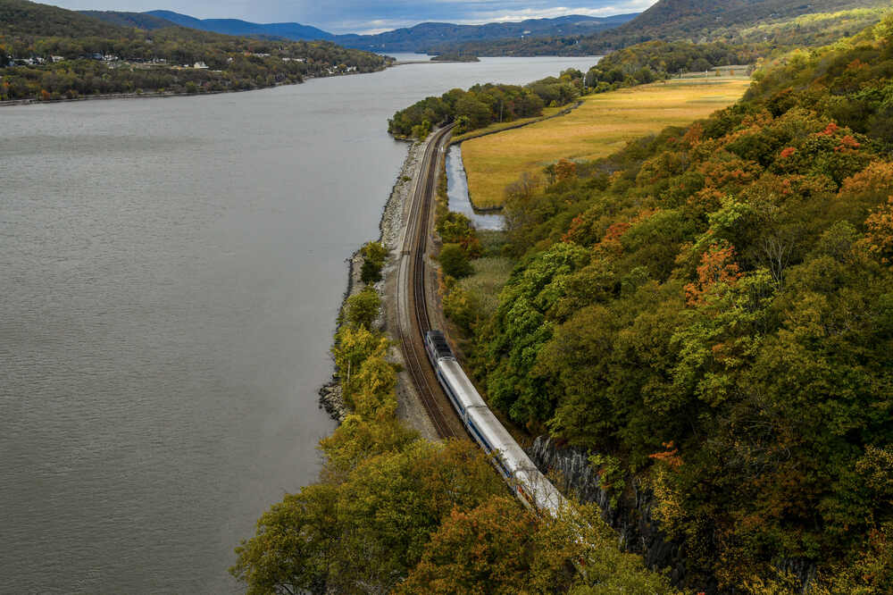
The initiative will focus first on a particularly vulnerable 20-mile section between Riverdale and Croton-Harmon. This stretch has experienced multiple weather-related disasters in recent years:
- In 2021, Tropical Storm Ida washed out a 110-year-old culvert north of Dobbs Ferry Station
- In October 2023, a private retaining wall collapsed near Tarrytown, sending 350 cubic yards of soil and 250 cubic yards of rock debris tumbling across all four tracks
- From 2021 through 2023, Metro-North reported approximately 480 incidents of downed trees along the right-of-way
Railway at Growing Risk
The plan addresses an urgent and worsening problem. Currently, more than 50% of the Hudson Line’s 74-mile route is vulnerable to coastal flooding during storms. By the 2050s, that number will jump to 80% as sea levels rise and coastal storms intensify.
“By the 2050s, 80 percent of the Hudson Line will be at increased risk of flooding due to rising sea levels and more frequent severe weather events,” warned Metro-North President Justin Vonashek. “The Hudson Line is a key economic driver for the Hudson Valley and it’s important that we make these crucial investments to protect the future of not only the railroad, but the entire coastal area.”
The MTA reports that nearly one-sixth of all Hudson Line tracks will face monthly high-tide flooding by the 2050s if no action is taken. This presents an existential threat to a railway that serves over 10 million riders annually, plus Amtrak passengers and CSX freight operations.
Comprehensive Infrastructure Rebuild
The Blueprint includes rebuilding several critical infrastructure components, most of which are over a century old:
- Culverts and drainage systems that manage water flow
- Retaining walls and slopes to prevent landslides
- Shoreline protections against erosion and tidal surges
- Track infrastructure, including raising track elevations in flood-prone areas
The plan also establishes system-wide design standards for the entire Hudson Line, including target track elevations, specifications for waterfront shoreline improvements, and performance criteria for drainage systems.
Similar Posts
Part of Broader Capital Investment
The Hudson Line Climate Resilience Blueprint is part of the MTA’s 2025-2029 Capital Plan, a $68.4 billion investment in the region’s transportation network. This historic funding package aims to improve reliability, accessibility, and sustainability across the system.
The MTA has scheduled a public Open House on Wednesday, April 23, at the Hastings-on-Hudson Library from 5:30 p.m. to 7:00 p.m. Officials will present details about the Blueprint and take questions from the public.
Increasing Flood Frequency
The Mott Haven Yard, a critical nine-acre facility where Metro-North’s Hudson, Harlem, and New Haven lines converge before heading into Grand Central Terminal, has flooded at least 13 times between July 2016 and October 2023. The MTA notes that these flooding incidents have become more frequent in recent years.
Other Metro-North lines face similar climate threats. The Harlem Line has experienced multiple washouts during major storms, including Tropical Storm Ophelia in September 2023 and Tropical Storm Ida in 2021, which caused flooding and debris problems between multiple stations.

The MTA reports that the New Haven Line faces less acute risks due to its higher average elevation, though sea level rise and torrential rain will impact it as well.
With flooding incidents becoming more frequent and projections indicating worsening conditions, this Blueprint represents a significant step toward protecting one of New York’s most vital transportation arteries.
Frequently Asked Questions
The Metro-North Hudson Line Climate Resilience Blueprint is an initiative by the Metropolitan Transportation Authority (MTA) to protect the Hudson Line rail corridor from climate change threats. It focuses on rebuilding critical infrastructure including culverts, drainage systems, retaining walls, slopes, shorelines, and tracks to withstand increased stormwater runoff, tidal flooding, and other extreme weather events. The plan prioritizes a vulnerable 20-mile stretch between Riverdale and Croton-Harmon and establishes design standards for the entire 74-mile route.
The plan is necessary because more than 50% of the Hudson Line’s 74-mile route is currently vulnerable to coastal flooding during storms, and this vulnerability is projected to increase to 80% by the 2050s due to rising sea levels and more frequent severe weather. The Hudson Line has already experienced significant disruptions from weather events, including washouts during Tropical Storm Ida in 2021 and a major mudslide in 2023 that covered all four tracks. With over 10 million annual riders depending on the Hudson Line, plus Amtrak and freight services, protecting this infrastructure from climate impacts is critical.
While the exact construction timeline hasn’t been specified in the MTA’s announcement, the Hudson Line Climate Resilience Blueprint is part of the MTA’s 2025-2029 Capital Plan. This suggests that major construction work would occur within this five-year window. The MTA is currently in the planning and public engagement phase, with the first Open House scheduled for April 23, 2025, at the Hastings-on-Hudson Library. Given the scope of the project and the 20-mile priority section, work will likely be phased over several years to minimize service disruptions.
The MTA has not yet released specific details about service impacts during construction. However, based on similar large-scale infrastructure projects, it’s likely that some work will be scheduled during off-peak hours, nights, and weekends to minimize disruption to commuters. The agency’s approach of bundling projects to maximize efficiency may also help reduce the overall duration of potential service adjustments. More information about construction scheduling and service impacts will likely be shared during the upcoming public engagement sessions.
The Hudson Line Climate Resilience Blueprint is part of the MTA’s larger 2025-2029 Capital Plan, which totals $68.4 billion for improvements across the region’s transportation network. While the exact budget allocation for the Hudson Line project hasn’t been officially confirmed across all sources, it represents a significant investment in protecting this critical transportation corridor from climate change impacts. The funding is designed to address infrastructure that in many cases is over a century old and vulnerable to increasing climate threats.
The MTA is hosting a series of Open Houses to engage with the public about the Hudson Line Climate Resilience Blueprint. The first Open House is scheduled for Wednesday, April 23, 2025, at the Hastings-on-Hudson Library from 5:30 p.m. to 7:00 p.m. It will feature a presentation by MTA Construction & Development representatives followed by a Q&A session. This will provide an opportunity for commuters and residents to learn more about the project and share their perspectives on climate resilience for the Hudson Line. Additional Open Houses are planned but dates have not yet been announced.


![Representative Image: European Starling [49/366]. Photo Source: Tim Sackton (CC BY-SA 2.0)](https://www.karmactive.com/wp-content/uploads/2025/04/Starlings-Drop-82-in-UK-Gardens-as-Birdwatch-2025-Reveals-Record-Low-Count-Since-1979-720x480.jpg)