A decade ago, creating an open-access picture of worldwide fishing activity couldn’t have been more attainable. However, thanks to advancements in satellite technology and computer learning, Global Fishing Watch (GFW) is becoming a reality. “Just a decade ago building a global picture of human activity would have been impossible. Today, Global Fishing Watch is making it a reality,” said experts from Global Fishing Watch.
Global Fishing Watch, an international charity co-founded by Google, released two new datasets ahead of World Oceans Day on June 8 to give everyone a complete picture of how human activity affects the seas, global industries, climate, biodiversity, and other areas. The datasets, which track worldwide ocean infrastructure and vessels that do not publicly broadcast their positions, can help improve policy discussions concerning offshore renewables development, provide information on carbon dioxide emissions from maritime vessels, and enable marine conservation. It collaborates with scientific institutions to provide new, free, publicly accessible data and analysis to better understand the ocean’s most pressing concerns.
Transparency—the act of making precise ocean and vessel data, as well as the policies and decisions that surround them, open and accessible to those who require and are affected by it—provides governments and other decision-makers with a scalable and equitable approach to ocean management.
Technologies used by Global Fishing Watch include vessel tracking, monitoring and analysis, sustainability, and management. Traditional methods of monitoring and surveillance are costly and often inefficient, making illegal, unreported, and unregulated fishing a low-risk, high-reward activity for nefarious operators. Transparency offers a new approach to the way fishing activities are monitored, vessel data is shared, and information is cross-referenced.
“The ocean creates oxygen, regulates weather, and provides essential nutrition and livelihoods for billions of people,” said GFW spokespeople, while reflecting on the critical role of the ocean. Despite its importance, “But our ocean is under immense pressure from human activity and climate change,” they added. Since its start, Global Fishing Watch’s data has helped governments manage ocean space and construct fourteen marine protected areas (MPAs) to conserve marine and coastal ecosystems.
Similar Posts
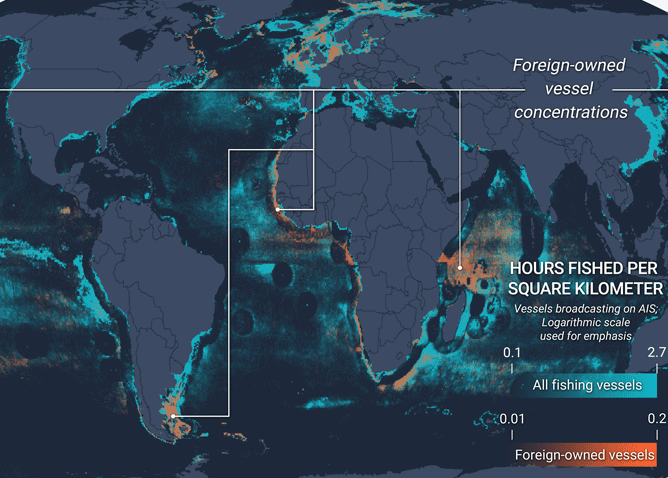
For instance, Ascension Island, an MPA in the Atlantic Ocean bordering Angola and Brazil, is bordered by tuna-rich fishing grounds. The government has hired Global Fishing Watch to watch over boats near their massive MPA and investigate how climate change affects the ecology.
The ocean is vast, yet few areas are devoid of human activities. This makes it difficult to manage its different resources, let alone ensure their sustainability. However, Global Fishing Watch is challenging this notion. “There’s a few hundred thousand of these boats – they’re usually larger boats that broadcast their GPS positions – and we can use that to create a map of all large vessels in the ocean that broadcast their GPS positions,” David Kroodsma from Global Fishing Watch said in a webinar. The technology uses automatic identification system or AIS to track vessels based on GPS positions broadcasted on radio, originally deployed to avoid collisions. Anyone with an internet connection can access the online platform, which provides a plethora of scientific information while also allowing people to monitor maritime areas and analyze vessel activities in near real-time.
More and more governments are realizing the crucial role of Google-backed Global Fishing Watch in monitoring and controlling fishing activities. In 2022, Papua New Guinea’s National Fisheries Authority, backed by the Fishing Industry Association, planned to publish its vessel monitoring data on the Global Fishing Watch map. By June 2023, it became the first Pacific country to do so. 50 purse seine tuna fishing vessels are now being tracked and openly displayed on the interactive map, enhancing transparency in one of the region’s largest tuna fisheries, which is a key source of protein for more than 9 million people in Papua New Guinea.
In 2023, Norway became the first European country to publish its vessel monitoring data on the Global Fishing Watch map. This system currently tracks around 600 industrial fishing vessels, primarily operating in Norwegian waters and the northeast Atlantic. “In terms of countries and regions that have benefited from Global Fishing Watch, I’d say we have a global approach,” Andrew Giacalone from GFW informed Karmactive by mail. Norway joins countries like Ecuador and Papua New Guinea in sharing their vessel monitoring data on GFW map.
“Our major focus is on commercial fishing – it is the most widespread human activity at sea,” GFW highlighted the scale of the challenge and the potential impact of their work. Transparency is introducing a fresh approach to how the ocean is watched over and eventually managed. Advances in technology and large-scale data are fast redefining our ability to develop fresh insights, and Global Fishing Watch aims to make this knowledge accessible to those who require it. When ocean and vessel data are shared publicly, experts can speed science, increase accountability, and contribute to fairer, wiser policies that safeguard fisheries and the people who rely on them.
They hope to create a comprehensive picture of what is going on across two-thirds of the planet’s surface by unlocking this digital ecosystem and putting information freely into the hands of those who need it and decision-makers who can act on it, illuminating what has previously been hidden and possibly illegal.
