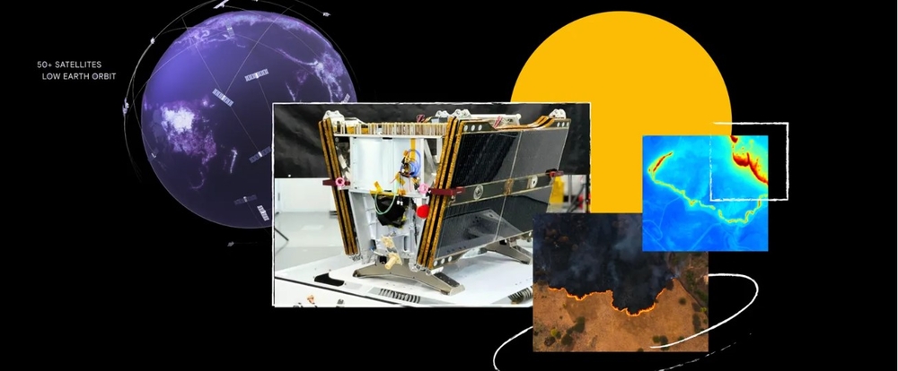
A game-changing satellite has just made its way into Earth’s orbit, aiming to revolutionize how we detect and respond to wildfires. The first FireSat satellite, launched by SpaceX, has officially made contact with Earth, marking the beginning of an ambitious project to create a constellation of over 50 satellites dedicated to wildfire detection.
The Technology Behind FireSat
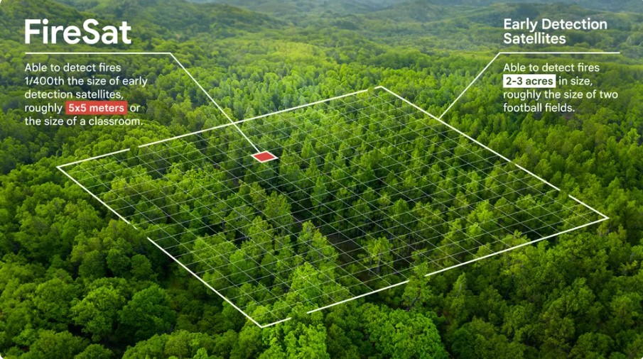
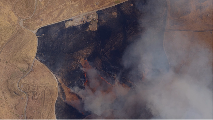
FireSat isn’t just another satellite—it’s specifically designed to detect wildfires as small as 5×5 meters, roughly the size of a classroom. Using advanced AI and multispectral infrared sensors, the satellite can distinguish between actual fires and other heat sources like industrial activity.
When fully operational, the FireSat constellation will provide updates every 20 minutes, a significant improvement over current satellite imagery that updates only every 12 hours. This rapid response time could dramatically change how emergency services handle wildfire threats.
“Current satellite imagery is often low-resolution, infrequently updated and unable to detect small fires,” explains Juliet Rothenberg, Product Director of Climate AI efforts at Google Research. For firefighters and communities at risk, this means they can now spot dangers before they grow into uncontrollable disasters.
The Personal Experience That Sparked Innovation
The push for better wildfire detection technology stems from real-world experiences. Juliet Rothenberg vividly recalls evacuating during a California wildfire four years ago: “After we evacuated, we constantly stared at satellite imagery to see whether the fire had crossed the road because if it had, we knew our community would burn.”
During that evacuation, Rothenberg and her neighbors waited hours for updates because better data “didn’t exist.” What shocked her most was discovering that “wildfire authorities didn’t have much better data” than she did.

A Collaborative Effort
FireSat is the result of an unprecedented collaboration between:
- Google Research, contributing AI expertise
- Muon Space, the satellite manufacturer
- Earth Fire Alliance, the nonprofit home for FireSat
- Gordon & Betty Moore Foundation, providing funding
Google.org, Google’s philanthropic arm, contributed $13 million to support the launch of the first satellite as part of its AI Collaboratives: Wildfires initiative.
Similar Posts
More Than Emergency Response
Beyond immediate disaster response, FireSat aims to address broader climate concerns. Chris Van Arsdale, who works on climate and energy projects at Google, emphasized the importance of “getting a handle on CO2 mitigation for wildfires.”
Wildfires create a vicious environmental cycle, as Rothenberg explains: “Warmer, dryer climates cause wildfires to occur more often and in new places. These fires release more CO2 that traps heat in the atmosphere, causing temperatures to rise and climate change to accelerate.”
The satellite data will contribute to a global historical record of fire spread, helping scientists better understand wildfire behavior. “FireSat is more than just an emergency response tool,” says Rothenberg. “It’s also an incredible tool for reducing greenhouse gas emissions. It’s actually really beautiful that the constellation contributes to reducing climate change—while also responding to it.”
The Journey to Launch
Developing FireSat required extensive testing and refinement. The team even loaded a plane with sensors to experiment with their progress. “The first time we used the plane, one of our team members lit a barbeque and a firepit in his backyard so we could fly the plane over and test it,” says Erica Brand, one of the project managers for FireSat. “And the sensors were able to pick it up.”
The satellite was launched from Vandenberg Space Force Base in California as part of SpaceX’s Transporter-13 mission. Google CEO Sundar Pichai publicly thanked SpaceX for providing “the ride” that carried FireSat into orbit, highlighting the collaborative nature of this technological advancement.

Building on Previous Work
FireSat isn’t Google’s first foray into wildfire response. It expands on work launched in 2020 that uses AI and satellite imagery to create wildfire boundary maps, which are integrated into Google Search and Maps to help people see wildfire locations and receive safety information.
While that earlier work made substantial progress, the team recognized the limits of existing satellite imagery. “Some satellites today take a picture about every five minutes, but they’re coarse,” explains Van Arsdale. “You’re lucky if you can see the city of San Francisco in the image. You’re certainly not going to see where a fire is until it’s a few acres in size.”
With FireSat’s ability to detect fires as small as a classroom, combined with AI that can rapidly compare spots with previous imagery while considering factors like nearby infrastructure and local weather, wildfire detection is entering a new era of precision and speed.
Frequently Asked Questions
FireSat is an AI-powered satellite designed specifically for wildfire detection. Unlike existing satellites that provide low-resolution images updated only every 12 hours, FireSat can detect fires as small as 5×5 meters (about the size of a classroom) and will provide updates every 20 minutes when the full constellation is operational. Its multispectral infrared sensors and AI capabilities allow it to distinguish between actual fires and other heat sources.
The FireSat constellation will eventually include more than 50 satellites. The first satellite has just launched, and while the exact timeline for the full constellation deployment hasn’t been specified in the sources, it’s described as becoming fully operational “in the coming years.”
FireSat is a collaborative effort between Google Research, Muon Space (satellite manufacturer), Earth Fire Alliance (the nonprofit home for FireSat), and the Gordon & Betty Moore Foundation. Google.org contributed $13 million to support the launch of the first satellite as part of its AI Collaboratives: Wildfires initiative.
FireSat uses a combination of multispectral infrared sensors and AI to detect wildfires. The AI rapidly compares real-time imagery with historical images of the same location, taking into account factors like nearby infrastructure and local weather conditions to determine if there’s a fire. This technology can distinguish between actual fires and random “noise” in the environment or sensor issues.
FireSat will help with climate change in two key ways. First, by enabling earlier detection and faster response to wildfires, it will help reduce the amount of CO2 released into the atmosphere from burning vegetation. Second, the data collected will contribute to a global historical record of fire spread, helping scientists better understand wildfire behavior and develop more effective prevention and mitigation strategies.
FireSat builds upon Google’s 2020 wildfire response work that used AI and satellite imagery to create wildfire boundary maps for Google Search and Maps. While that earlier system provided helpful information about approximate wildfire size and location, it relied on existing satellite imagery with limitations in resolution and update frequency. FireSat dramatically improves both aspects, able to detect much smaller fires (5×5 meters) and provide updates every 20 minutes rather than every several hours.