As Tropical Cyclone Alfred inches toward southeast Queensland, residents are preparing for what could be days of destructive winds, dangerous storm surges, and potentially life-threatening flooding. Here’s everything you need to know about the approaching storm and how to stay safe.
Current Status: Slow-Moving Cat 2 System
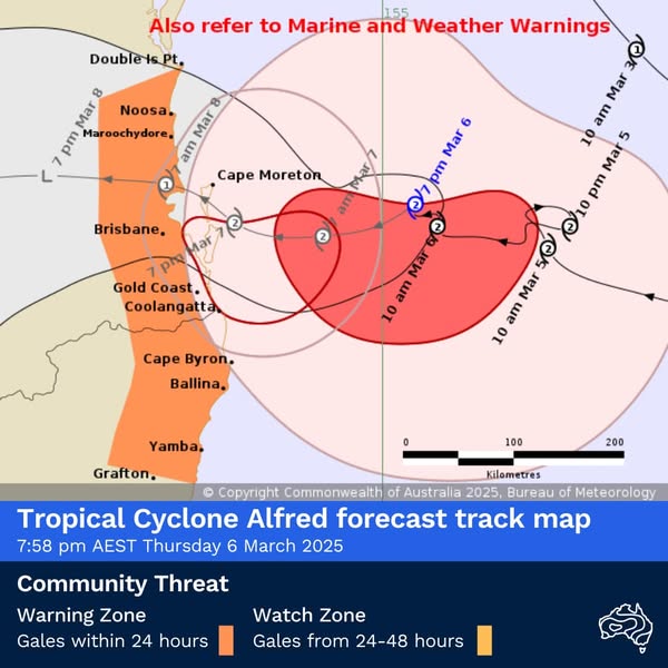
As of March 6, 2025, Tropical Cyclone Alfred remains a Category 2 system located approximately 245 kilometers east of Brisbane, with wind gusts near the center reaching up to 130 km/h. The system is moving westward at about 7 kilometers per hour.
“Tropical Cyclone Alfred remains a Category two system and is currently 240 kilometers east of Brisbane. It is moving west at around seven kilometers per hour towards the south east Queensland coast as we speak,” meteorologist Matthew Callopy confirmed.
The Bureau of Meteorology (BOM) expects Alfred to approach the Bay Islands as a Category 2 system before weakening to a Category 1 as it crosses the mainland coast during the early hours of Saturday morning.
What’s Coming: Four Major Threats
Queensland Premier David Crisafulli summarized the situation clearly: “There are waves, there is wind, there is rainfall and there will be flooding.”
1. Destructive Winds
Wind gusts up to 155 km/h are expected near and south of the cyclone‘s center during coastal crossing. Cape Moreton has already recorded gusts of 96 km/h, with Double Island Point at 82 km/h and Gold Coast Seaway at 80 km/h.
2. Heavy Rainfall
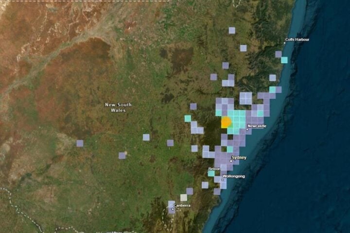
BOM forecasts rainfall totals between 350-450mm over 24 hours, with some areas potentially receiving up to 800mm total. The heaviest falls are expected on the southern flank of the system, particularly in the far southeast corner of Queensland and elevated parts of New South Wales.
“This heavy to intense rainfall is expected to produce both flash and riverine flooding,” Callopy warned.
3. Dangerous Storm Surge
Storm tides could rise one meter above the highest astronomical tide, with exposed locations around the Gold Coast and Redland Southern Bay Area potentially seeing surges up to 1.5 meters.
4. Powerful Waves
Significant waves between 4-6 meters have already been observed, with forecasts suggesting they’ll peak between 7-8 meters tonight and tomorrow before gradually easing throughout the weekend. The Gold Coast has recorded extreme wave heights of 12.3 meters.
Flood Risk Areas: Know Your Zone
Flood watches are currently in effect from the Mary River all the way to the Gold Coast border. Major Flood Warnings have been issued for northeastern New South Wales, stretching down toward the Mid North Coast.
BOM meteorologist Sarah Scully emphasized: “A Tropical Cyclone Warning is current, extending from Double Island Point all the way down to just shy of Grafton, including the heavily populated parts of the Sunshine Coast, Brisbane, Gold Coast and the Northern Rivers district of New South Wales.”
Emergency Responses: What Officials Are Doing
Brisbane:
- Temporary Refuge Shelters at RNA Showgrounds (already open), with Chandler Arena and Kedron Wavell opening tomorrow
- All sandbag stations will close by 8 PM Thursday
- Kerbside bin collections suspended
- Transport services (CityCat, ferry, buses) suspended
Gold Coast:
- Evacuation centers at Runaway Bay Indoor Sports Centre, Burleigh Waters Community Centre, and Pimpama Sports Hub
- DIY sandbagging station at Carrara Sports Precinct
“We have established 23 Swiftwater hubs with specialist firefighter rescue teams, swift water rescue teams to provide immediate response and capacity across those impacted communities,” said Steve Smith, Commissioner of Queensland Fire Department.
Stay or Go? Making the Right Choice
For those in flood-prone areas, authorities recommend:
- Check flood risk maps on your local council’s disaster dashboard
- If possible, stay with friends or family in higher ground areas
- Use evacuation centers as a last resort if you have no alternatives
“If you are in flood risk area, start lifting your important items, your furniture from low lying areas in your house and lifting them to higher ground, putting your valuables in a waterproof container so that you can take them with you,” advised Acting Police Commissioner Shane Chellepy.
The Recovery Plan: Already in Motion
Jake Ellwood, CEO of the Queensland Reconstruction Authority, stressed that recovery planning is already underway: “Those that are prepared definitely bounce back better after an event. There is no doubt about it.”
The recovery process will include:
- Immediate cleanup operations
- Damage assessments
- Emergency repairs to critical infrastructure
- Long-term reconstruction
“The Queensland Reconstruction Authority is here for the long haul. We are side by side with community through the process that is recovery,” Ellwood said.
Similar Posts
What NOT To Do: Dangerous Behaviors
Despite clear warnings, authorities are struggling with people engaging in risky behaviors:
“I’m flabbergasted with some of the footage I’m seeing of kids [near the water],” said Acting Chief Superintendent Peter Miles. “Parents, your kids are with you for the next four days at least — please keep an eye on them.”
Acting Gold Coast Mayor Donna Gates was more direct: “I’m staggered that people would be so stupid. It just makes no sense that people would be doing that at this time.”
The City of Gold Coast warned that “reckless actions” could result in fines up to $16,100.
Mental Health Support
For those experiencing anxiety or stress related to the cyclone, support services are available:
- Lifeline: 13 11 14
- Community Recovery Hotline: 1800 173 349
Stay Informed
- Download the Gold Coast Disaster Dashboard app for real-time updates
- Visit disaster.qld.gov.au for emergency information
- Monitor the Bureau of Meteorology website for cyclone tracking
- Listen to ABC local radio for emergency broadcasts
Remember: “If you do the preparation, it is a system that you will be able to handle,” Premier Crisafulli reassured residents.

Missing Insights: What You Might Not Know
Orographic Effect
Areas like the Scenic Rim and Hinterland could see amplified rainfall as moist air is forced upward by mountain terrain, creating more intense precipitation than coastal areas.
Post-Cyclone Dangers
After the storm passes, be alert for:
- Mold growth in water-damaged homes
- Electrocution risks from submerged power outlets
- Contaminated floodwaters carrying sewage or chemicals
Insurance Considerations
Contact your insurer immediately after the cyclone passes to begin the claims process. Document all damage with photos before cleanup begins.
The cyclone’s slow movement means we’re facing not just a weekend event but potentially days of ongoing impacts across southeast Queensland and northern New South Wales. Stay vigilant, follow official advice, and remember: preparation is key to staying safe.