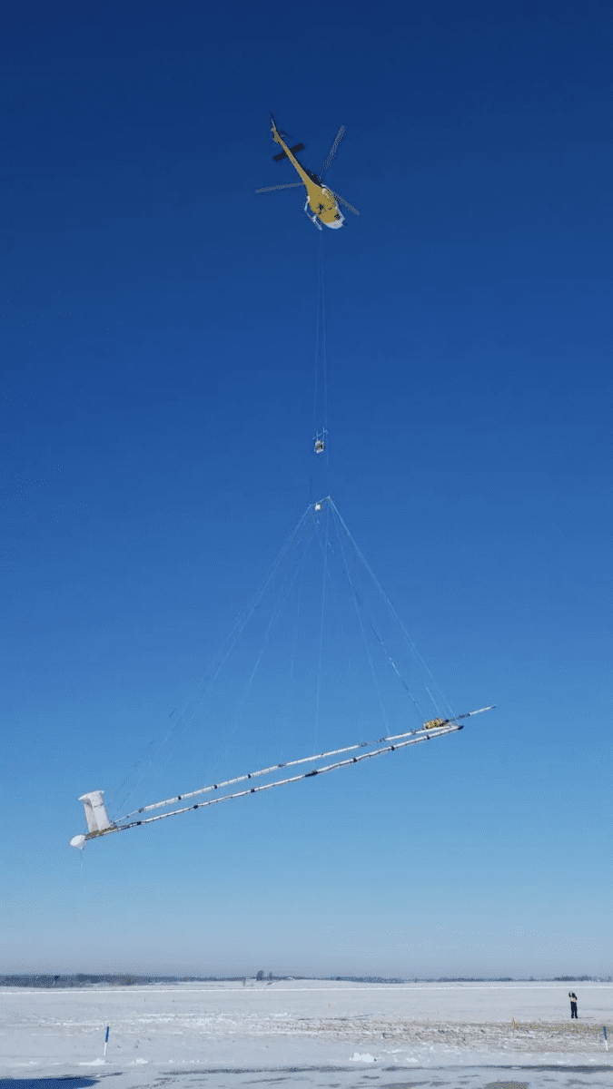
The Upper Black Squirrel Creek Groundwater Management District in El Paso County, Colorado, is turning to advanced technology to locate water sources in Eastern El Paso County. They have presented a new technology called AEM (Aero Electric Magnetic) mapping, which involves a low-flying helicopter towing an electronic device capable of “seeing” 2,000 feet below the surface to identify “rechargeable” aquifers. The AEM mapping technology provided by a company called AGT will enable the Groundwater Management District to map the basin down to a depth of 2,000 feet, including bedrock aquifers. The goal is to map the areas where water can be stored in replenishable aquifers. These aquifers will be significant in creating a sustainable water source for the region.
The groundwater from aquifers remains as an essential source of drinking water and even for irrigation. In recent times, the alluvial aquifer in the area have depleted, impacting the region. The district is dependent on nonrenewable Denver basin aquifers and water from Colorado Springs. With the AEM mapping technology, officials will have actual data about the underground resources, allowing them to make informed decisions about the future management and allocation of water in Colorado. The helicopter equipped with the AEM mapping device will fly over the area starting on June 7th, weather permitting. The system uses transmitting signals into the ground from the front of the helicopter to measure the time delay for the signal to reach the back. This information helps determine the soil’s resistance and classify it as sand or clay, which is crucial in identifying suitable areas for groundwater recharge.
Similar Post
Groundwater supplies approximately 40% of the water in non-drought years and 60% during droughts in California. However, groundwater has been overexploited gradually over the years which has led to water scarcity. Recharging aquifers through rain and snowmelt is essential, but California’s climate is known for its variability, alternating between extreme drought and flood. To make groundwater sustainable, water managers like Aaron Fukuda, General Manager of the Tulare Irrigation District, aim to capture floodwater and snowmelt quickly and divert it into the sandy areas that facilitate groundwater recharge. Clay, despite being porous, is the least permeable sediment and acts as an aquitard, hindering water flow. On the other hand, sand and gravel provide the necessary permeability for effective groundwater recharge. Efforts are being made to map these different sediment types, focusing recharge efforts on sandy areas.
The Tulare Irrigation District collaborated with Stanford University in the past to map aquifers and recharge areas, diverting surface water into the groundwater system for storage during wet years. This allows water to be utilized during drought periods, essentially using the groundwater system as a large underground reservoir. The implementation of the Sustainable Groundwater Management Act in 2014 has required local water agencies to develop and implement groundwater sustainability plans by 2040. Similar technologies and techniques are being used in other districts to better understand and manage groundwater resources. By employing advanced mapping technologies like AEM, water managers can make informed decisions to ensure the sustainable use of groundwater and meet the water needs of the region.
