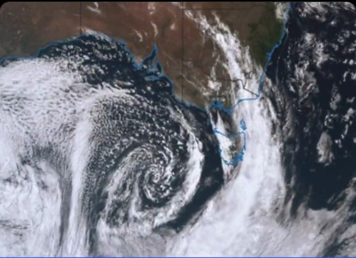
A powerful storm is brewing off Queensland’s coast. Weather experts are tracking a tropical low just 505 kilometers from Cairns that’s getting stronger by the hour.
Right now, the winds near the storm’s center are hitting 75 kilometers per hour – strong enough to knock over loose outdoor furniture. Some wind gusts are even reaching 100 kilometers per hour, creating potentially dangerous conditions.
“This could bring gusty conditions, showers and increased swell to the central and northern Queensland coast,” says Angus Hines from the Bureau of Meteorology. He warns the storm could become a category three cyclone by week’s end. The warm waters of the Coral Sea are helping the storm gain strength and intensity.
What makes this weather event unusual is its location. Two other storm systems are currently circling Australia – one up north and another down south. These three systems are creating a complex weather pattern, making it harder for weather experts to predict exactly what will happen next.
The storm isn’t moving fast – only about 6 kilometers per hour. But its slow pace is concerning. “This one is quite interesting just because it drifts quite far south,” explains Jonathan How from the weather bureau. “We don’t often see a tropical system move this far down the coast.”
For people living along Queensland’s coast, from Cooktown to Capricornia, strong wind warnings are already in place. The ocean is getting rougher, with bigger waves expected by mid-week. The stronger the system becomes, the more intense these ocean conditions could get.
Similar Posts
Weather experts aren’t sure yet where the storm will go next. It might stay out at sea, or it could swing closer to the coast. Either way, they’re watching it closely. The storm could even reach the Wide Bay area, much further south than usual for these types of weather systems.
For now, the message is clear: keep an eye on weather updates, especially if you live near the coast. While there’s no immediate danger, the storm’s slow movement means conditions could change over the coming days.
Another storm system is spinning far off Western Australia’s coast, about 1,000 kilometers out to sea. This one’s heading away from land, so it’s less of a worry for mainland Australia.

The next big storm will be named either Alfred or Bianca. Whichever system intensifies into a cyclone first will receive the first name.
This is very different from how tropical storms usually behave in this region. Normally, these systems stay in the far north, but this one’s breaking the usual patterns. It’s a reminder that nature can be unpredictable, and it’s best to stay prepared and informed.