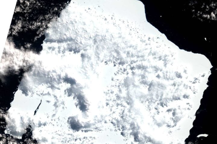
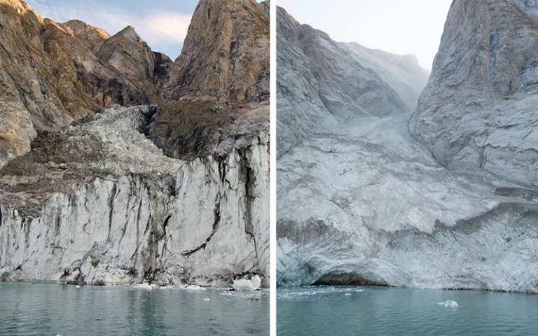
Before and after the massive landslide that dumped 33 million cubic meters of ice and rock into a Greenland fjord, triggering a 650-foot-high ‘megatsunami’ that shook the Earth for nine days.
Dr. Kristian Svennevig and his colleagues, who studied deeper about the cause and effects of the event, now believe that climate change set the stage for these landslides by melting a glacier at the base of the mountain and destabilizing enough ice and rock to fill 10,000 Olympic-size swimming pools. As global temperature rise melts Earth’s polar regions, devastating landslides like this one could become more common.
The research team published their findings in the Science journal. When seismic monitoring networks first detected the activity, scientists were surprised for two reasons. First, the signal is much more dispersed than the typical tight squiggle produced by an earthquake on a seismograph, an instrument used to record ground tremors. “Instead, it oscillated with a 92-second-interval between its peaks, too slow for humans to perceive,” according to a statement from the University of California San Diego, an institution that contributed to the research. Second, the signal was strong for nine consecutive days. Typical earthquakes decay more quickly: the average quake lasts only a few seconds or minutes.
Lead author, Dr. Kristian Svennevig, from the Geological Survey of Denmark and Greenland (GEUS), said “When we set out on this scientific adventure, everybody was puzzled and no one had the faintest idea what caused this signal. All we knew was that it was somehow associated with the landslide. We only managed to solve this enigma through a huge interdisciplinary and international effort.”
Scientists around the world quickly began working to get to the bottom of this strange signal. The megatsunami destroyed nearly $200,000 worth of infrastructure at an abandoned research center on Ella Island, but no one was injured. Online discussions finally led to reports of a massive landslide on a mountain dominating a remote fjord in eastern Greenland on September 16, 2023.
To determine if the landslide was related to the mysterious tremors, the research teamdigitally reconstructed the landslide and the resulting quakes. They did this using a combination of earthquake recordings from around the world, field measurements, satellite imagery, and computer simulations. The researchers used supercomputers to simulate a 650-foot-high megatsunami that was triggered by 33 million cubic yards of rock and ice crashing into the fjord.
The waves sloshed back and forth within the fjord in a phenomenon known as a seiche. The researchers concluded that the sloshing was a nine-day period of seismic activity that shook the Earth last year. “Ultimately, a large amount of geophysical observations and numerical modeling by researchers from many countries was needed to piece together the puzzle and get a full picture of what happened,” said Robert Anthony, a co-author of the U.S. Geological Survey Hazards Program earthquake, in a statement.
According to the researchers, the findings demonstrate “complex, cascading hazards” driven by the effects of climate change on Earth’s polar regions. “Climate change is shifting what is typical on Earth, and it can set unusual events into motion,” co-author Alice Gabriel, a seismologist at the University of California San Diego, said in a statement.
Similar Posts
Over the past year, dozens of scientists from around the world have tried to figure out what this signal was. Some seismologists thought their instruments were broken when they began detecting vibrations in the ground in September, said Dr Stephen Hicks, a co-author of the study and a seismologist at University College London. “When I first saw the seismic signal, I was completely baffled,” he said. “Never before has such a long-lasting, globally travelling seismic wave, containing only a single frequency of oscillation, been recorded. This inspired me to co-lead a large team of scientists to figure out the puzzle,” Dr Hicks added.
The seismologists traced the signal to eastern Greenland, but couldn’t pinpoint a specific location. They then reached out to colleagues in Denmark, who had received reports of a tsunami triggered by a landslide in a remote part of the region called Dickson Fjord. The result was a nearly year-long collaboration among 68 scientists from 15 countries, who reviewed seismic, satellite and ground data, as well as tsunami wave simulations to solve the puzzle.
What happened is called a “cascading hazard,” said Dr. Svennevig, and it all started with human-caused climate change. For years, the glacier at the base of an enormous mountain rising nearly 4,000 feet above Dickson Fjord had been melting, as is happening with many glaciers in the rapidly warming Arctic. As the glacier thinned, the mountain became increasingly unstable before finally collapsing on September 16 last year.
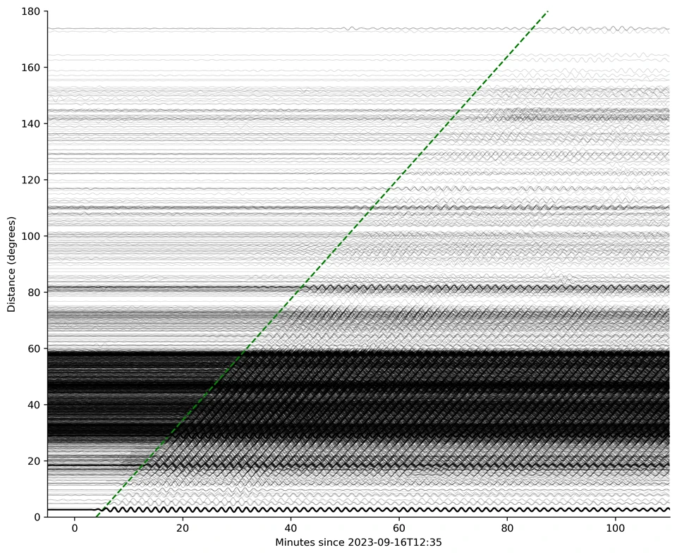
The subsequent megatsunami, one of the highest in recent history, unleashed a wave that became trapped in the narrow, winding fjord for over a week, sloshing back and forth every 90 seconds. The phenomenon, called a “seiche,” refers to the rhythmic sloshing of a wave in an enclosed space, similar to water splashing back and forth in a bathtub or cup. One of the scientists even tried (and failed) to recreate the impact in his own bathtub.
No one was injured in the tsunami, though it washed away centenarian cultural heritage sites and damaged an empty military base. But this expanse of water is a commonly used cruise ship route. If one had been there at the time, “consequences of a tsunami wave of that magnitude could have been devastating,” the study authors wrote.
Eastern Greenland had never before experienced a landslide and tsunami like this, said Dr. Svennevig. It shows that new areas of the Arctic are “connecting” for this type of climate-driven event, he added. As the Arctic continues to warm (in recent decades, the region has warmed four times faster than the rest of the world), landslide-triggered megatsunamis may become more common and have deadly aftermaths.
In June 2017, a tsunami in northwest Greenland killed four people and swept away homes. This time, the landslide of rock and ice occurred at the peak of a mountain that previously towered 1.2 kilometers above the fjord due to the thinning of glaciers at the mountain’s base in recent decades as a result of global warming.
The resulting megatsunami is one of the highest in recent history according to numerical simulations, data from the local network of oceanographic sensors, and satellite imagery. “We wouldn’t have discovered or been able to analyse this amazing event without networks of high-fidelity broadband seismic stations around the world, which are the only sensors that can truly capture such a unique signal,” said co-author Thomas Forbriger, from Karlsruhe Institute of Technology.


